Data Files for the MCSC’s Geospatial Trucking Industry Decarbonization Explorer (Geo-TIDE) Tool Now Openly Accessible on Amazon Web Services
July 16, 2025
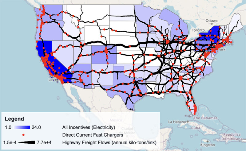
Snapshot of the Geo-TIDE tool.
To support better information sharing, which can accelerate discoveries, data files for the MCSC’s Geospatial Trucking Industry Decarbonization Explorer (Geo-TIDE) are now accessible on Amazon Web Services (AWS). To start a project using the dataset, researchers do not need to purchase storage, and will only pay for the computing services they use. AWS, through its Open Data Sponsorship Program, is covering the costs of the storage and transfer of the data, so that it can be accessed and analyzed in the cloud by researchers around the world. By making this dataset openly accessible on the cloud, the MCSC aims to enable researchers, policymakers, and industry stakeholders to explore and assess freight decarbonization opportunities at scale. Public code, documentation, and tutorials support transparency and reuse, while AWS hosting ensures fast, scalable access for analysis and application development.
Consisting of approximately 1.5 GB of data across more than 400 files, this dataset provides GeoJSON layers developed by the MCSC to support geospatial analysis of opportunities to transition U.S. trucking fleets to low-carbon energy carriers using the Geo-TIDE tool. The layers are synthesized from diverse federal sources – integrating datasets from the US Department of Transportation, the Environmental Protection Agency, and the Energy Information Administration, among many others – and have been geometry-simplified, normalized, and thematically grouped to support interactive planning and decision-making.
Now hosted on AWS through the Open Data Sponsorship Program, the dataset is optimized for cloud-native access: GeoJSON files can be queried directly via Amazon S3, with no need for local storage or preprocessing, enabling real-time analysis with the MCSC’s Geo-TIDE tool or external GIS platforms.

“With Geo-TIDE’s data now available on AWS, we hope that the information can be leveraged to support customized assessments of fleet transition opportunities among a broader audience, leading to implementable and scalable solutions."
“With Geo-TIDE’s data now available on AWS, we hope that the information can be leveraged to support customized assessments of fleet transition opportunities among a broader audience, leading to implementable and scalable solutions,” said Danika Eamer, MCSC Impact Fellow and the lead developer of Geo-TIDE.
Geo-TIDE data themes that are now accessible on AWS include truck freight flows, lifecycle vehicle emissions, grid emissions and electricity pricing, hydrogen and charging infrastructure, state-level regulations and incentives, and energy demand from fleet electrification. A subset of layers also supports a thought experiment estimating cost savings from pooled charging infrastructure.
The AWS Open Data Sponsorship Program covers the cost of storage and egress for publicly available, high-value, cloud-optimized datasets. AWS works with data providers to democratize access to data by making it available for analysis on AWS; develop new cloud-native techniques, formats, and tools that lower the cost of working with data; and encourage the development of communities that benefit from access to shared datasets. Through the program, AWS has democratized access to petabytes of data, including satellite imagery, climate and weather data, genomic data, and data used for natural language processing. The full list of publicly available datasets is available on the Registry of Open Data on AWS.
Learn more and access the GeoJSON files for Geo-TIDE on AWS.