New MCSC Mapping Tool Integrates Multiple Datasets to Support Resilience Planning and Decarbonization
March 10, 2023
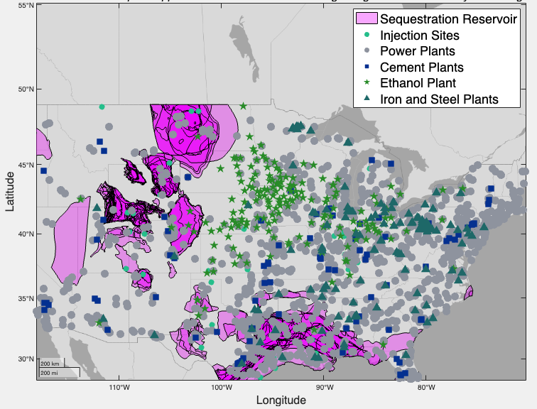
Snapshot of the Mapping Tool.
The MCSC’s new Interactive Geospatial Mapping Tool helps member companies visualize and understand the barriers to resilience planning and decarbonization. Developed by Sydney Sroka, MCSC Postdoctoral Impact Fellow, in collaboration with MCSC members and colleagues, the mapping tool hosts a unique combination of data necessary for addressing decarbonization and resilience planning.
The mapping tool prioritizes data that support the decisions MCSC member companies felt were inadequately supported by existing tools. It integrates datasets on carbon capture and sequestration (CCS) infrastructure, electric grid carbon intensity, natural hazard risk, vegetation, transportation routes, and population.
“The information currently in the mapping tool is all public data, but we uniquely combine these disparate sources and we specifically add new data layers when our member companies identify a need that additional data would help address. For example, most industrial facilities need to be located far away from population centers and would ideally be located in regions less impacted by climate change – so population and natural hazard risks are some of the data layers that the tool can cross-reference to support site selection decisions,” explains Sroka. “These data are all important for assessing crucial decarbonization and resilience planning decisions, but don’t all exist anywhere else in one tool.”

The tool’s capabilities
“This stage of the project is geared towards understanding what the data needs of large companies with complex value chains are, which data gaps are inhibiting multiple industries from doing the decarbonization and resilience planning they would like to be doing, and what are effective approaches towards facilitating the interdisciplinary and cross-sectoral collaboration that is necessary to address climate change-related challenges,” says Sroka.
One example of a stakeholder planning decision that the mapping tool supports is how to strategically deploy carbon capture throughout a supply chain. The tool’s features and filters integrate the regional carbon intensity of the grid, the availability of compatible CCS infrastructure, and the projected natural hazard risk to help study differences in the cost and carbon reduction potential of CCS at each facility.
Another actionable insight the mapping tool helps support is identifying regions where the natural hazard risk is high and the number of transportation routes is low, since those communities could find it difficult to evacuate and/or receive disaster recovery supplies. To do this, the tool integrates geospatial data layers including natural hazard risk, social vulnerability, and transportation routes.
A collaborative process
The value of the mapping tool extends beyond its decision support functionalities. The process of iterating with the companies and collecting their feedback helped identify data gaps that, if bridged, would enable multiple sectors to chart out more comprehensive and robust paths forward.
For example, the mapping tool has helped facilitate discussions between member companies about their desire for a centralized location where CO2 emitters and CO2 transportation/storage specialists could engage with each other and the relevant geospatial data. This currently represents a substantial data and communication gap that, if bridged, would unlock huge potential in the CCS marketplace.
Since development began in February 2022, the MCSC team has completed five iterations of tool development and stakeholder feedback, and found that collaboratively building the platform together facilitated productive interdisciplinary conversations. MCSC member companies from different industries worked together to explore the cross-sectoral applicability of the data and its usefulness for cross-value-chain collaboration aligned around common challenges.
“Developing this map has been a very collaborative and dynamic process,” says Sroka. “Being able to directly interact with our industry partners has allowed us to rapidly prototype solutions that address their needs at increasing levels of specificity.”
Sroka also gathered feedback by running a workshop at the MCSC Symposium in October 2022. Participants from the member companies gained hands-on experience with the mapping tool, exploring its capabilities and even competing to see who could complete a site selection task the fastest.

“I think one of the most valuable contributions from this project is allowing multiple industries to collaboratively identify overlapping data needs,” Sroka commented. “By having these interdisciplinary discussions, we can identify critical data gaps, strategize about how to bridge them together, and better plan for the impacts that climate change is having both today and in the future.”